

Introduction
Materials and Methods
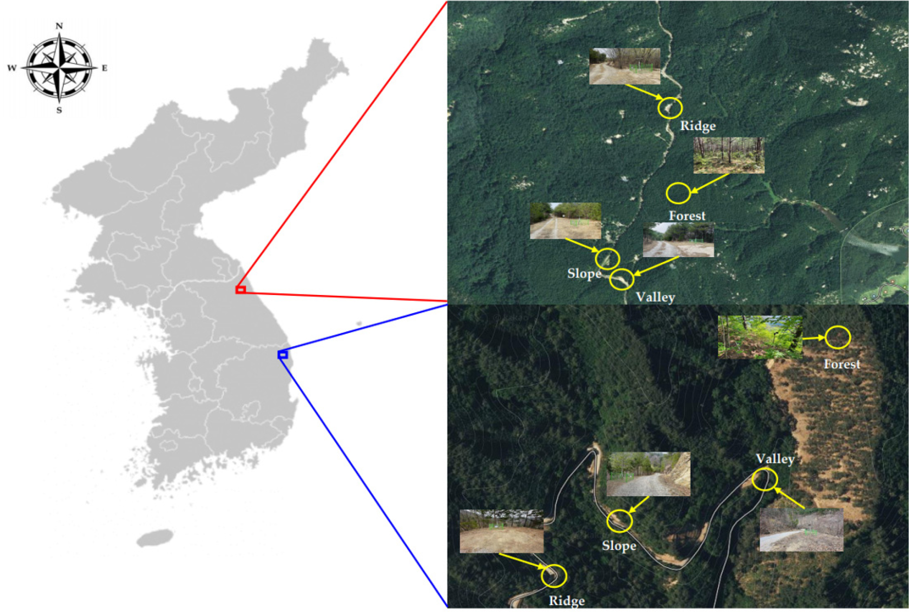
Study Sites
Research survey and analysis methods
Results and Discussion
Analysis of wind characteristics by region
Conclusion
Introduction
Forest roads are essential for managing and administrating forest resources, serving as multifunctional forest infrastructure facilities such as forest tours, ecological education, and mountain leisure sports (Ji et al., 2015). In South Korea, there are a total of 25,847 km of forest roads (8,670 km in national forests and 17,177 km in private forests), and the density of forest roads is 4.1 m per ha (Korea Forest Service, 2024b). While the density is somewhat lower than in major forestry countries such as Germany with 54.0 m/ha, Austria with 50.5 m/ha, Japan with 24.1 m/ha, Canada with 11.3 m/ha, and Finland with 5.8 m/ha (Korea Forest Service, 2024c), the Korea Forest Service is striving to increase the density to 5.5 m/ha by 2030 through the 5th National Forest Road Master Plan (2021-2030) (Korea Forest Service, 2021).
Due to recent climate changes, the spring season has the highest risk of forest fires due to rising temperatures, dry atmosphere, and strong winds in some areas (National Institute of Forest Science, 2024), with forest fires becoming more frequent and larger yearly. Over the last 10 years (2014-2023), there have been 5,668 forest fires (an average of 567), totaling 40,037 ha (an average of 4,004 ha) (Korea Forest Service, 2024a). A forest fire is defined as ‘large’ when the affected area is more than 100 ha, and a ‘super large’ when the affected area is more than 1,000 ha. Initial firefighting is critical to prevent large forest fires (Jeon, 2020). Initial firefighting requires rapid deployment and mobilization of equipment and personnel. Forest roads are essential infrastructure for this purpose (Choi et al., 2023), providing facilities for forest management and administration, also serving as fuel breaks and firebreaks for the initial extinguishment of forest fires (Dimitrakopoulos, 2000; Forman and Alexander, 1998; Matthew et al., 2021; Narayanaraj and Wimberly, 2011, 2012; Price and Bradstock, 2010; Thompson et al., 2021).
Previous studies on the effects of wind and forest fire along forest roads have shown that trees around forest roads are exposed to more wind than trees in roadless areas (Abdi et al., 2020), and that winds spin and cause more damage when they enter open pathways such as roads (Bagheri, 2012). As mentioned earlier, forest roads function as initial fire control and firebreak lines for forest fires, but forest roads can also negatively impact forest fires by increasing wind strength (Hong et al., 2023). The average wind strength within forests and on forest roads was found to be 0.1-0.4 m/s and 3.4-5.0 m/s, respectively, with higher wind strength on forest roads (Einzmann et al., 2022). ollah Hosseini et al. (2016) found that the distance from forest roads correlated with the area affected by forest fires, with each 1 m increase in distance increasing the forest fire areas by 1.545 m2. However, these previous studies depend on conditions such as weather characteristics and micro-topography, and detailed analytical studies to identify direct effects within forests and on forest road facilities are lacking in South Korea and abroad.
This study examined the wind characteristics in forests according to forest road facilities by analyzing the forest location (valley, ridge, slope) and wind characteristics (changes in wind direction and speed) during spring and summer seasons in GG and UG, major forest fire risk areas in South Korea.
Materials and Methods
Study Sites
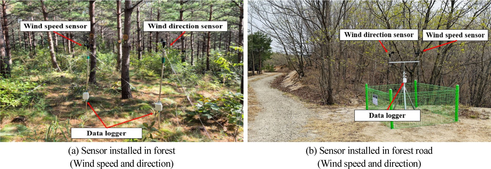
The study sites were three main forest roads (effective width 3 m) (valley, ridge, and slope) located at Mountain 4, Yachon-ri, Jukwang-myeon, Goseong-gun, Gangwon-do, South Korea (GG, 38°17'47"N, 128°28'57"E), where a large forest fire occurred. Other sites were in the forest, three main forest roads (effective width of 3 m) located at Mountain 29, Sogwang-ri, Geumgangsong-myeon, Uljin-gun, Gyeongsangbuk-do, South Korea (UG, 37°01'23"N, 129°10'59"E), and one site in the forest. Wind speed and direction sensors were installed within the forests and at each forest road location to analyze the wind characteristics according to seasonal changes (Table 1 and Fig. 1).
Table 1.
Characteristics of the two study sites
| Site | A | B |
| Place | Mt. 4, Yachon-ri, Jugwang-myoen, Goseong-gun, Gangwon-do | Mt. 29, Sogwang-ri, Geumgangsong-myoen, Uljin-gun, Gyeongsangbuk-do |
| Point of the compass | Southeast | Southwest |
| Slope (°) | 15-20 | 25-30 |
| Elevation (m) | 50-310 | 560-1040 |
| Tree species | Pinus densiflora in Gangwon province | |
| Stand type | Artificial forest | Natural forest |
| Site volume (m /ha)3 | 39.9 | 326.7 |
| DBH1) (cm) | 6.0 (6.0-6.0) | 28.0 (6.0-72.0) |
| Height (m) | 4.0 (4.0-4.0) | 14.0 (5-5) |
Research survey and analysis methods
Configuration of wind (wind speed and direction) measurement devices and data collection method
To investigate the characteristics of wind changes such as wind speed and wind direction by forest and forest road locations, we created one plot in the forest and three plots at each forest road location, at a height of 2 m, considering the sensor installation location and site conditions (Fig. 2). The wind speed and direction sensors and dataloggers configuration to collect data are shown in Table 2. Wind speed and wind direction data were collected from April 11 to September 22, 2024 (165 days) with a data sampling frequency of 1-minute average values (one average value per 3-second interval) (Einzmann et al., 2022), separately for spring and summer periods. The wind speed data using the National Institute of Forest Science Automatic Weather Station(AWS) was selected based on the sites adjacent to each study site. Therefore, data from Masan (2084) and Seongdae (2008) meteorological networks in the Goseong area and Baekbyeongsan (7917) and Agusan (7895) meteorological networks in the Uljin area were collected and analyzed using the linear interpolation method with the following equation (Choi, 2019):
Table 2.
Specifications of wind speed, wind direction, and data logger used in the study
Where, : distance of location 1
: distance of location 2
: Wind speed (distance of location 1)
: Wind speed (distance of location 2)
Wind direction analysis
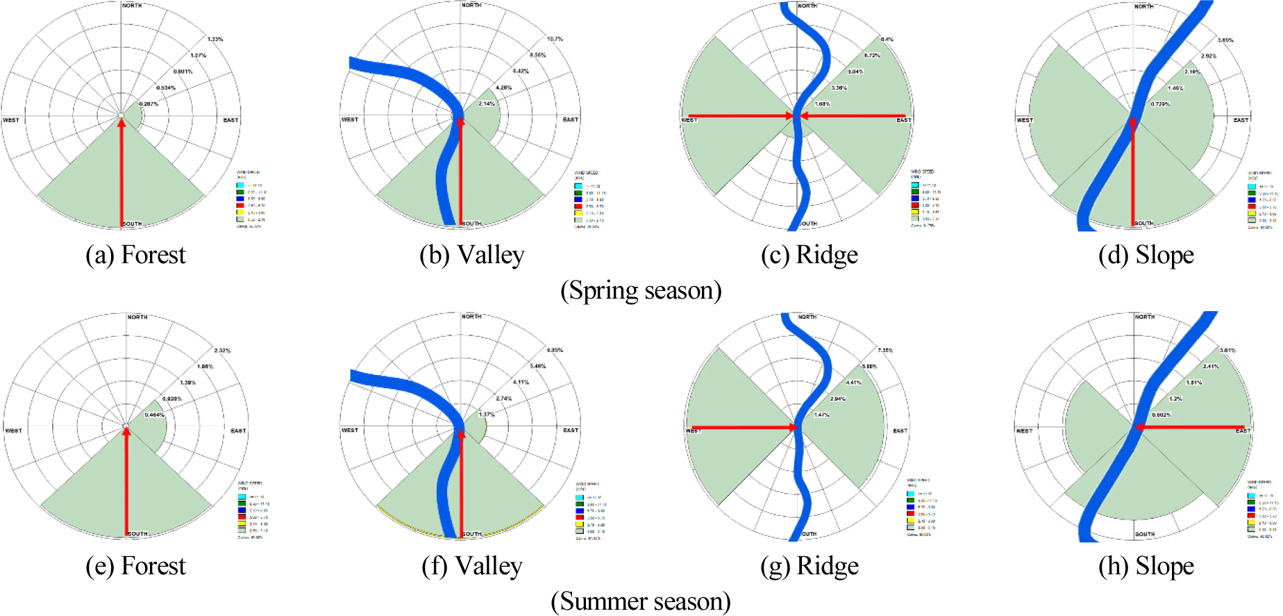
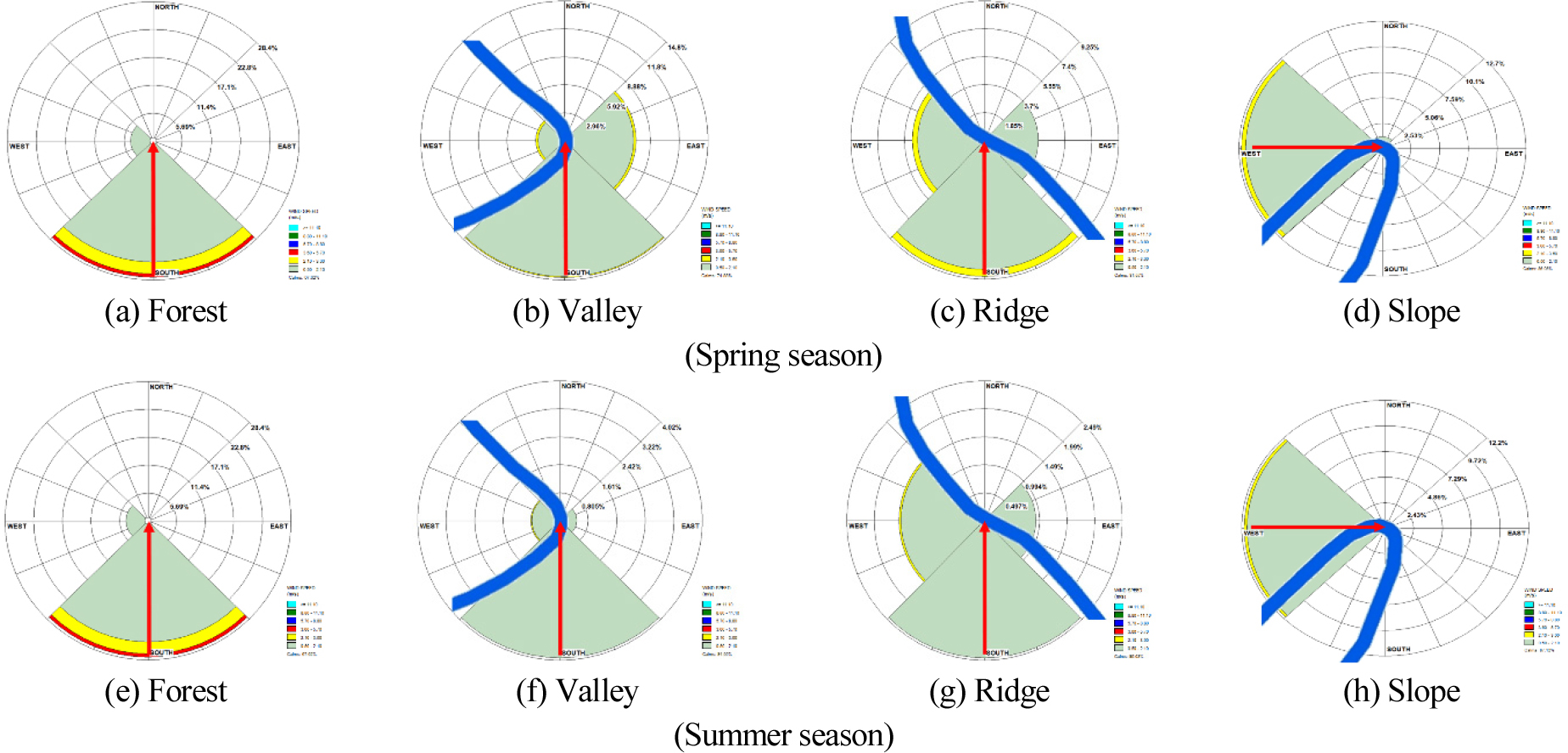
WRPLOT View 8.0.2 (Lakes software, Ontario, Canada) analyzed rose plots of wind direction variations within the forest and by forest road location, including data year, month, day, hour, wind direction, and wind speed. The rose plots were used to check from which direction the wind was blowing. The wind rose plots were overlaid with the forest road data to analyze the characteristics of forest road facilities and wind.
Statistical analysis
A statistical analysis of wind speed was performed based on forest and road location. T-tests for the average value of each item and one-way analysis of variance (ANOVA analysis) data were performed to assess overall significance (p < 0.05). The program used for statistical analysis was SPSS 23.0 (IBM Inc., Armonk, NY, USA).
Results and Discussion
Analysis of wind characteristics by region
Analysis of wind speeds by region
This study divided GG and UG to analyze wind speeds by region regarding wind characteristics within forests and latitudinal locations.
The wind speeds within the forest and by forest road location in GG are shown in Table 3. During the spring season, the average wind speed within the forest was 0.05 m/s, and the average wind speed by forest road location was 0.22 m/s on the ridge, 0.17 m/s in the valley, and 0.10 m/s on the slope. During the summer period, the average wind speed within the same forest was 0.05 m/s, and the wind speed by location in descending order was ridge at 0.16 m/s, valley at 0.11 m/s, and slope at 0.09 m/s. Changes in wind speed by location and period were statistically significant (p < 0.05), and the changes in wind speed by forest road location were statistically significant (p < 0.05) in both spring (F-value 8.064) and summer (F-value 11.426) (Table 4).
Table 3.
Comparative analysis of wind speeds by region, period, forest, and forest road location (Site 1: Goseong-gun, Gangwon-do, and Site 2: Uljin-gun, Gyeongsangbuk-do)
| Wind speed (m/s) | |||||||||||||||||
| Items | Site 1 (Goseong-gun, Gangwon-do) | ||||||||||||||||
| Spring season | Summer season | ||||||||||||||||
| AWS1) |
Forest (Control) | Valley | Ridge | Slope | AWS1) |
Forest (Control) | Valley | Ridge | Slope | ||||||||
| Avg. | 0.52 | 0.05 | 0.172) | 0.222) | 0.102) | 0.54 | 0.05 | 0.112) | 0.162) | 0.092) | |||||||
| Min. | 0.17 | 0.00 | 0.01 | 0.00 | 0.00 | 0.09 | 0.00 | 0.00 | 0.00 | 0.00 | |||||||
| Max. | 1.39 | 0.23 | 0.62 | 0.74 | 0.50 | 1.92 | 0.67 | 0.95 | 0.89 | 0.84 | |||||||
| S.D.3) | 0.35 | 0.08 | 0.19 | 0.19 | 0.15 | 0.44 | 0.11 | 0.20 | 0.18 | 0.16 | |||||||
| Items | Site 2 (Uljin-gun, Gyeongsangbuk-do) | ||||||||||||||||
| Spring season | Summer season | ||||||||||||||||
| AWS1) |
Forest (Control) | Valley | Ridge | Slope | AWS1) |
Forest (Control) | Valley | Ridge | Slope | ||||||||
| Avg. | 0.50 | 0.44 | 0.302) | 0.262) | 0.182) | 0.54 | 0.21 | 0.092) | 0.102) | 0.162) | |||||||
| Min. | 0.27 | 0.00 | 0.01 | 0.05 | 0.00 | 0.13 | 0.00 | 0.00 | 0.00 | 0.00 | |||||||
| Max. | 0.27 | 2.15 | 0.97 | 0.87 | 1.13 | 1.49 | 1.82 | 0.32 | 0.63 | 1.35 | |||||||
| S.D.3) | 10.43 | 0.54 | 0.20 | 0.21 | 0.24 | 0.32 | 0.32 | 0.07 | 0.12 | 0.27 | |||||||
Table 4.
One-way ANOVA of wind speed by region, period, forest, and forest road location (Site 1: Goseong-gun, Gangwon-do, and Site 2: Uljin-gun, Gyeongsangbuk-do)
| Source1) | DF | Sum of squares | Mean squares | F-value | Prob > F | |
|
Site 1 (Goseong-gun, Gangwon-do) | Spring season | 3 | 0.601 | 0.200 | 8.064 | 0.001 |
| Summer season | 3 | 0.930 | 0.310 | 11.426 | 0.001 | |
|
Site 2 (Uljin-gun, Gyeongsangbuk-do) | Spring season | 3 | 1.295 | 0.432 | 3.975 | 0.009 |
| Summer season | 3 | 1.339 | 0.446 | 9.065 | 0.001 | |
The average wind speed in UG was 0.44 m/s in the forest during the spring season (Table 3), followed by 0.30 m/s in the valley, 0.26 m/s on the ridge, 0.18 m/s on the slope, and 0.18 m/s on the forest road. During the summer, the average wind speed was the highest at 0.21 m/s in the forest, followed by 0.16 m/s on the slopes, 0.10 m/s on the ridges, and 0.09 m/s in the valleys at the forest road locations. The changes in wind speed by location and period were statistically significant (p < 0.05), and the changes in wind speed were statistically significant (p < 0.05) in both spring (F-value 3.975) and summer (F-value 9.065).
In GG, higher average wind speeds were observed in the spring and summer periods by road location than within the forest, while in UJ, higher average wind speeds were observed in the forest than within the road location for both periods. Both regions showed an increase in average wind speeds in spring compared to summer. These results are similar to those of Einzmann et al. (2022), who observed higher average wind speeds in more open forest roads than in forests. Furthermore, the results were also similar to the observation that the impact of wind increased when it entered open areas such as roads compared to forests (Bagheri, 2012).
According to data from the Korea Meteorological Administration, the average wind speeds over the past 30 years in Gangwon-do and Gyeongsangbuk-do were 1.1-2.3 m/s and 1.2-3.6 m/s, respectively (Korea Meteorological Administration, 2024a, 2024b). The National Institute of Forest Science found that wind, which is the most influential factor in the spread rate of forest fires, increases the spread rate of wildfires 26 times more when blowing at a speed of 6 m/s on a slope of 20° compared to no wind (National Institute of Forest Science, 2024). The slopes in the two regions vary widely from 15° to 30°, but the wind speeds are much lower than the 6 m/s above and are not expected to impact the spread of forest fires. The forest-type conditions of the two regions are identical in tree species. The difference in wind speed is likely due to other conditions, such as tree diameter and elevation. This aspect needs further analysis based on weather conditions and micro-topography.
Since only the spring and summer seasons were considered in this study, it is recommended that monitoring be done outside of these periods for further analysis.
Analysis of wind direction by region
Similar to the wind speed analysis for the two regions, the wind direction observation time was based on the time from 0:00 to 23:00 to compare the wind direction in the forest and by forest road location. Fig. 3 shows the results of the wind direction analysis by location in GG. During the spring season, the main wind in the forest flowed from south to north, and by forest road location, the main wind direction was south in the valley, west and east in the ridge, and south in the slope. During summer, the primary wind flow was from south to north, the same as during spring. By forest road location, the main winds flowed south in the valleys, west on the ridges, and east on the slopes. Overall, the main winds in the forest flowed from south to north, and in the valleys, the winds flowed from the south regardless of the time, while in the other analyzed areas, wind directions varied. The overall wind direction did not affect the forest roads during the spring and summer.
In UG, the main wind flowed from south to north within the forest during the spring period, the same as in GG. The average wind speed was higher (GG: 0.44 m/s, UG: 0.44 m/s) (Fig. 4). By forest road location, the main winds flowed south in valleys and ridges and to the west on slopes during spring. In summer, the same main winds were observed in valleys, ridges, and slopes, with higher wind speeds analyzed in spring. In UG, as with GG, the overall wind direction did not affect the forest roads (Figs. 3 and 4). Although previous studies presented some results on wind speed both domestically and internationally (Abdi et al., 2020; Einzmann et al., 2022), the study of wind characteristics through wind direction is still lacking.
This study examined only spring and summer periods; it is necessary to analyze all seasons. Further refinements are needed to consider the two regions' different weather conditions and micro-topography.
Conclusion
This study examined the influence of forest roads on the spread of forest fires by analyzing wind direction and speed characteristics by forest road location in areas with a risk of large forest fires in GG and UG. The wind speed during the spring and summer seasons showed that the wind intensity tended to change in the forest and by the location of forest roads in both regions. The wind direction was influenced by forest road facilities regardless of the period and season, likely to be strongly influenced by local weather conditions and micro-topography, requiring further analysis under various conditions.
Forest roads are essential facilities that enable the initial control of forest fires and the rapid deployment and movement of firefighting personnel. Future research is expected to carry out a comprehensive and detailed analysis of wind characteristics on forest roads, providing a basis for predicting the direction of forest fire control and spread by building a long-term database considering various parameters such as season and topography.
